

GPSTrack app for iPhone and iPad
4.4 (
464 ratings )
Photo & Video
Navigation
Developer: John Bafford
1.99 USD
Current version: 2.2.1, last update: 8 years agoFirst release : 26 Jun 2010
App size: 1.4 Mb
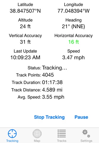
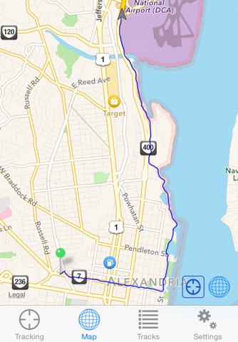
GPSTrack allows you to use the GPS receiver in your iPhone or iPad to show your current location and create a log of your travels, showing you a map of your path, updated in real-time.
GPSTrack can track your location while in the background, so you can continue to use your iPhone for other tasks. (Continued use of GPS running in the background can dramatically decrease battery life.)
Saved tracks can be exported via e-mail in GPX and KML formats, useful if you want to geotag photos from a camera that doesnt have GPS support.
Pros and cons of GPSTrack app for iPhone and iPad
GPSTrack app good for
I bought this app to track our explores. We just got some ATVs and live in an area with LOTS of trails, and few of them are documented - it is all word-of-mouth. This app works great, it doesnt require a cell signal to track, it just uses the iPhones built in GPS. It creates pretty accurate tracks and tells you a lot of nice info as you are tracking. It also exports into a Google-friendly and garmin-friendly format.
The only suggestions I have so far are:
- To be able to bulk export, OR simply have a "next track / previous track" button while exporting/ viewing tracks. It is tedious to go into one track, export it, go back to the track list, find the next one, export it, and so on.
- To be able to adjust the point intervals - you can select "only record accurate points" but it will record every second no matter what. It would be an easy bit of code to record points every 1, 5, 15, 30, 60, 120 seconds and so on.
- Caching maps - if you leave an area with data the app will "cache" the map and you can still see the immediate area. Would be AWESOME if the app would cache more of the area, much like google earth caches as you browse - then you could go off the grid and still see a cached map with your track on it.
That is it - with the above features it would be more than perfect. Thanks for this app! Im getting friends and family to buy it too, and well start documenting the trails and start making public maps… fun stuff.
Nothing fancy here but it gets the job done and does it well. No bells or whistles just tracking and clean effective way to export gpx files by email. Great app.
Some bad moments
I purchased on the recommendation of Tim Grey, a photographer and educator that I respect. Maybe it worked on his phone but on mine it randomly added points to my track that were thousands of feet away. Thought something might be wrong with the phone. Contacted Apple but no help there. Sent a support request to John Bafford but never received a response. Apparently John is happy to continue collecting money while not maintaining or supporting the app. Finally found PDF Maps which works great and showed there is nothing wrong with my phone.
I quite like this app. I wanted to be able to track my walking and this does the trick.
I run a security company and I use this app in my mobile units. It has not only keep track where each unit been, but it also improved the quality of work of my employees. So, I will do something that I dearly do. That is give it a 5 star rating. Please keep the updates coming. Thank you!
This application is exactly what I was looking for! I use it for flying, and it actually does two things for me:
1. Record the flight track, obviously
2. Keep the GPS running in the background, so I can switch between my flying GPS app and other apps without losing GPS lock on satellites!
Well done!
Not clear on why your not allowing the program to run on the ipod touch 4g. With the right accessories like the TomTom Car Kit for iPod Touch this should work perfectly.
Im a pilot, and I wanted something I could use to track my flight, which this program does just fine, but then be able to review it later. This program tracks the flight just fine by showing you a nice blue line on the map and telling you a position, altitude and speed IF you are looking at it during the actual tracking. When you complete the track and go to review it later it tells you nothing more then a date, that nice blue line again, duration ouf track and the distance traveled. You cant review you speed during different sections of the track, altitude, direction of travel or anything, just that nice blue line again. Ill give it to them for being able to track me precisely and draw a nice line in the map of my track traveled but what good is telling me the altitude, speed, heading and anything else it boasted to show if you can see none of them when reviewing each track, just the blue line drawn on the map? Obviously Im not impressed and will be purchasing another program to do what this one should have.